River Depositional Landforms
Rivers, through their continuous flow and interaction with the land, shape the earth’s surface in various ways, one of which is the creation of depositional landforms. These landforms are a result of the deposition of sediments carried by rivers. Understanding these formations is essential in comprehending the dynamic processes of the Earth’s surface.
Types of River Depositional Landforms
Alluvial Fans
Alluvial fans are fan-shaped deposits formed at the base of steep mountain slopes. They occur when a fast-flowing river abruptly enters a flat plain, causing the water to slow down and deposit sediments. Over time, these deposits accumulate, forming a fan-shaped landform.
Types of River Depositional Alluvial Fans
- Braided Alluvial Fans: Braided alluvial fans are characterized by multiple channels that diverge and converge as they transport sediment down the slope of a mountain. These channels frequently shift and braid, resulting in a network of interconnected channels that deposit sediment across a wide area at the base of the fan.
- Conical Alluvial Fans: Conical alluvial fans have a classic fan-shaped appearance, with sediment deposited in a broad, cone-like structure at the base of a steep mountain slope. The sediment is carried by fast-flowing rivers and is deposited as the river exits the narrow valley onto a flatter plain, forming a distinct cone-shaped landform.
- Colluvial Alluvial Fans: Colluvial alluvial fans are formed by the accumulation of sediment that has been eroded from the slopes of nearby hills or mountains and transported downslope by gravity. The sediment accumulates at the base of the slope, gradually building up to form a fan-shaped deposit.
- Alluvial Aprons: Alluvial aprons are broad, gently sloping deposits of sediment that extend outward from the base of a mountain or hill. They are formed by the gradual deposition of sediment carried by streams and rivers, creating a broad apron-like landform that gradually merges with the surrounding terrain.
Deltas
Deltas are depositional landforms formed at the mouths of rivers where they enter oceans, seas, or lakes. As rivers carrying sediment-laden water reach calmer bodies of water, the velocity decreases, leading to sediment deposition. Deltas typically have intricate networks of channels and are highly fertile regions.
Types of River Depositional Delta Landforms
- Arcuate Deltas: Arcuate deltas are characterized by their curved or arc-shaped coastline. They typically form when rivers deposit sediment in a fan-like pattern, causing the coastline to gradually extend outward in a concave shape. Arcuate deltas are common in areas where wave action and tidal currents play a significant role in shaping the coastline.
- Birdfoot Deltas: Birdfoot deltas derive their name from their resemblance to the splayed toes of a bird’s foot. They typically have multiple distributary channels that extend outward from the main river channel, resembling the toes of a bird’s foot. Birdfoot deltas often form in areas with low wave energy and minimal tidal influence, allowing distributaries to extend far into the surrounding body of water.
- Cuspate Deltas: Cuspate deltas have a triangular or cusp-shaped coastline, with prominent points or cusps extending outward into the body of water. They form in areas where sediment deposition is influenced by wave refraction and longshore drift, leading to the formation of triangular-shaped landforms protruding into the sea or lake.
- Estuarine Deltas: Estuarine deltas occur in areas where rivers flow into estuaries, which are semi-enclosed coastal bodies of water where freshwater from rivers mixes with saltwater from the ocean. These deltas are characterized by their complex network of distributaries and extensive marshlands, which are influenced by tidal fluctuations and sediment deposition within the estuarine environment.
Floodplains
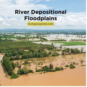
Floodplains are flat, low-lying areas adjacent to rivers that experience periodic flooding. These floods deposit layers of fertile sediment, enriching the soil and supporting diverse ecosystems. Floodplains play a crucial role in regulating water flow and mitigating flood risks.
Types of River Depositional Floodplains
- Active Floodplains: Active floodplains are those areas adjacent to rivers that regularly experience flooding during high-water events. These floodplains are characterized by their dynamic nature, as they are subject to frequent inundation and deposition of sediment during flood events. Active floodplains play a crucial role in regulating river flow and maintaining ecosystem health.
- Abandoned Floodplains: Abandoned floodplains are former floodplain areas that have been abandoned by the river due to changes in river course or channel avulsion. These floodplains may be located at a distance from the active river channel and are typically characterized by older sediment deposits and less frequent flooding. Abandoned floodplains may still retain features such as oxbow lakes and meander scars from previous river courses.
- Incised Floodplains: Incised floodplains are characterized by their deeply incised river channels, which have cut down into the surrounding floodplain sediments. These floodplains typically occur in areas with steep gradients or where rivers have experienced significant erosion, resulting in a narrow, steep-sided channel surrounded by relatively flat floodplain terrain. Incised floodplains may still experience periodic flooding, but the depth of the channel limits the extent of inundation.
- Backwater Floodplains: Backwater floodplains are low-lying areas located upstream of natural or artificial barriers, such as dams or levees, where water levels rise during high-flow events. These floodplains are characterized by their relatively calm water conditions and slow flow velocities compared to the main river channel. Backwater floodplains play a vital role in flood attenuation and sediment deposition, helping to reduce flood risks downstream.
Levees
Levees are natural embankments along the banks of rivers formed by successive layers of sediment deposited during flood events. They act as barriers, confining the river within its channel during high water levels, thus reducing the risk of flooding in adjacent areas.
Types of River Depositional Levee Landforms
- Natural Levees: Natural levees are formed along the banks of rivers as a result of successive flood deposits. When rivers overflow their banks during flood events, they deposit sediment along their banks, gradually building up raised embankments known as natural levees. These levees help confine the river within its channel during high-water events, reducing the risk of flooding in adjacent areas.
- Artificial Levees: Artificial levees are man-made embankments constructed along riverbanks to mitigate flood risks and protect adjacent areas from inundation. These levees are typically constructed using materials such as soil, rock, or concrete and are built up to a height above the surrounding terrain to contain floodwaters within the river channel. Artificial levees may be reinforced with vegetation or other materials to enhance their stability and effectiveness.
- Crevasse Splays: Crevasse splays are levee-like landforms that form when rivers breach their natural or artificial levees during flood events. When a levee is breached, floodwaters flow onto adjacent floodplain areas, depositing sediment as they spread out across the landscape. Over time, these sediment deposits build up, forming natural levee-like features known as crevasse splays.
- Back Levees: Back levees are secondary levees that form behind natural or artificial levees and provide additional protection against flooding. These levees may form naturally as sediment is deposited behind primary levees during flood events, or they may be constructed artificially to enhance flood protection measures. Back levees help contain floodwaters within the river channel and reduce the risk of inundation in low-lying areas adjacent to the river.
Formation Processes of River Depositional Landforms
Sediment Transport
Rivers transport sediment through a process called erosion, where particles are dislodged from the riverbed and banks. This sediment is then transported downstream by the river’s flow, eventually reaching areas where the velocity decreases, leading to deposition.
Depositional Processes
Deposition occurs when the velocity of the river decreases, causing it to lose its capacity to carry sediment. Factors such as changes in gradient, channel width, and flow rate influence the deposition process, leading to the formation of various landforms.
Characteristics and Features of Each Landform
Alluvial Fans
- Fan-shaped deposits
- Coarse sediment particles
- Proximal to mountainous regions
Deltas
- Triangular shape
- Distributaries and sedimentary layers
- Highly fertile soil
Floodplains
- Flat, low-lying areas
- Subject to periodic flooding
- Rich in sediment and nutrients
Levees
- Natural embankments
- Formed by successive flood deposits
- Mitigate flood risks
Importance of River Depositional Landforms
River depositional landforms play significant roles in various aspects of human life and the environment. They provide fertile soil for agriculture, support diverse ecosystems, regulate water flow, and mitigate flood risks. Understanding their formation and characteristics is crucial for effective land use planning and conservation efforts.
Human Interactions and Impact
Human activities such as urbanization, agriculture, and river channel modifications can significantly impact river depositional landforms. Alterations to natural river processes can disrupt ecosystems, increase flood risks, and degrade water quality. Sustainable management practices are essential to minimize these negative impacts.
Management and Conservation Strategies
Effective management and conservation of river depositional landforms require integrated approaches that consider ecological, social, and economic factors. Strategies may include land-use planning, habitat restoration, floodplain zoning, and sustainable agriculture practices. Collaboration between stakeholders is key to ensuring the long-term health and resilience of these ecosystems.
Conclusion
River depositional landforms are dynamic features shaped by the continuous interaction between rivers and the landscape. Understanding their formation processes, characteristics, and significance is essential for sustainable land management and conservation. By implementing effective management strategies, we can preserve these valuable ecosystems for future generations.
FAQs
- Why are river depositional landforms important? River depositional landforms provide fertile soil, support diverse ecosystems, regulate water flow, and mitigate flood risks, making them essential for human well-being and environmental health.
- How do human activities impact river depositional landforms? Human activities such as urbanization, agriculture, and river channel modifications can disrupt natural processes, leading to habitat destruction, increased flood risks, and degraded water quality.
- What are some conservation strategies for river depositional landforms? Conservation strategies may include land-use planning, habitat restoration, floodplain zoning, and sustainable agriculture practices aimed at preserving the integrity and function of these ecosystems.
- What is the significance of floodplains in river systems? Floodplains act as natural buffers during flood events, absorbing excess water and sediment, thereby reducing flood risks downstream and replenishing soil fertility through sediment deposition.
- How can individuals contribute to the conservation of river depositional landforms? Individuals can contribute by supporting sustainable land management practices, participating in conservation efforts, and advocating for policies that prioritize the protection of river ecosystems.

